
Civil Defence Updates, Warnings and Information
)
Civil Defence Updates - 2026
4 June 2026 - 10am
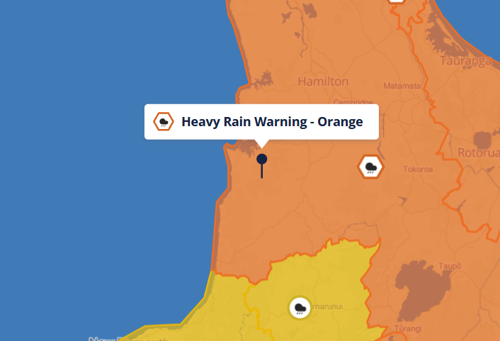
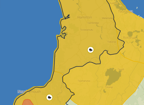
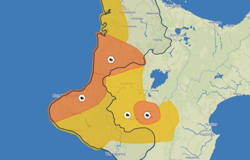
Update as at 10am on Friday 5 June 2026:
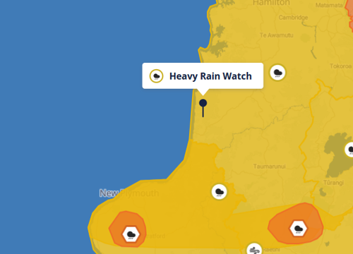
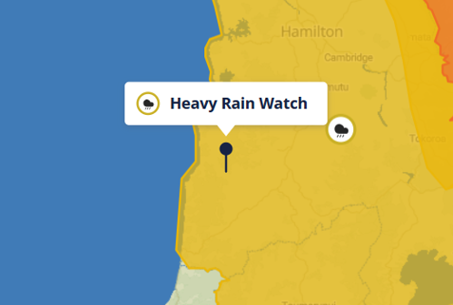
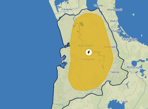
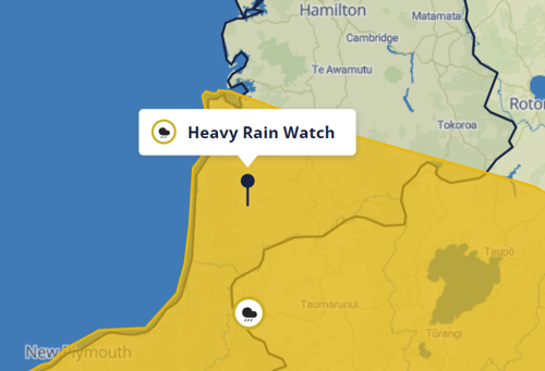
The heavy rain weather watch has been updated to 1pm-11pm on Friday 5 June.
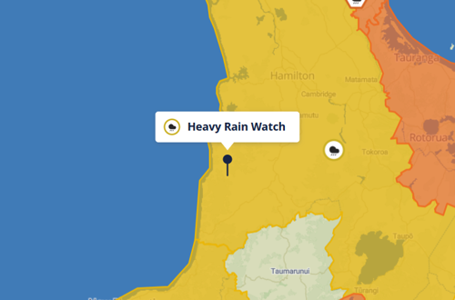
Update as at 9pm on Thursday 4 June 2026:
The heavy rain weather watch has been extended to 11pm on Friday 5 June.
Take care.
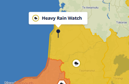
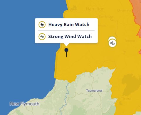
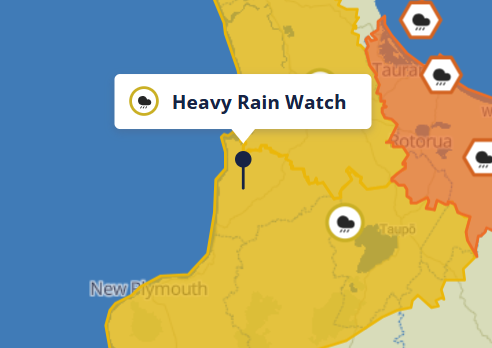
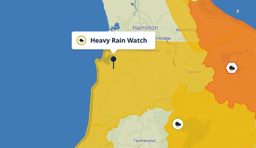
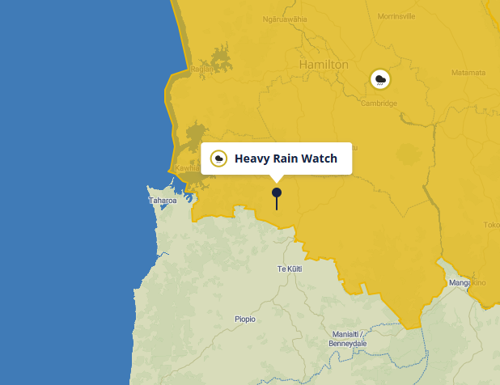
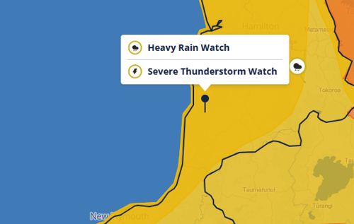
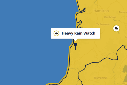
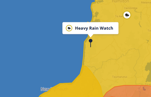
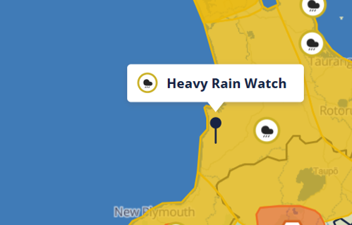
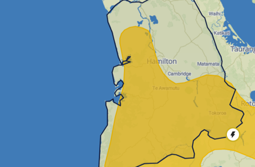
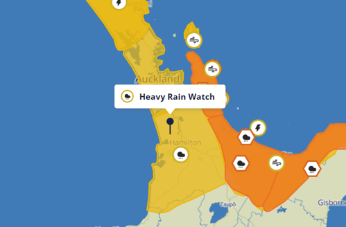
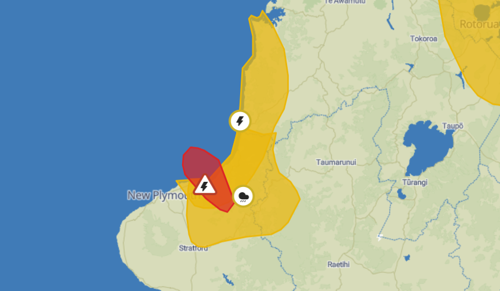
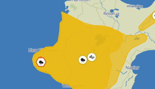
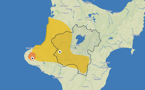
Heavy rain watch for Friday 5 June
🌧️ Looks like winter weather is setting in.
Metservice has issued a heavy rain watch for our district for tomorrow - it is valid from 3am to 9pm Friday 5 June.
Forecast: Periods of heavy rain, and amounts may approach warning criteria. Thunderstorms possible from afternoon. Moderate chance of upgrading to a Warning.
Saturday is not looking good either, particularly for our sports teams.
As always, stay safe and drive to the conditions.
2 June 2026 - 11.40am
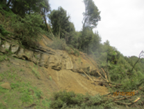
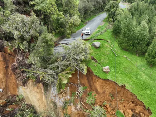
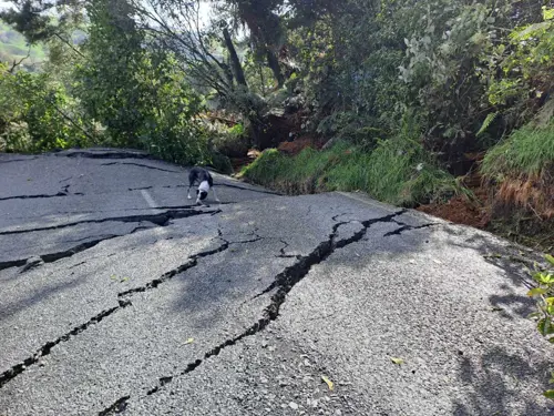
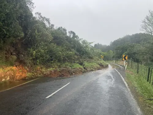
Urgent notice from NZTA - SH3 Awakino Gorge
NZTA have CLOSED SH3 through the Awakino Gorge because significant rainfall has made the route unsafe for travel.
The closure is in place from the rest area near the Awakino Historic Tunnel through to the intersection of SH3 with Manganui Road.
The number one priority is keeping people safe. NZTA have not made this decision lightly, but current conditions mean the road is currently not safe for traffic to use.
Road users are being advised to use SH4 and SH1 as the alternative state highway route and should not travel to the closure area. Please follow all signage, traffic management, and any instructions from onsite staff.
A geotechnical engineer is on site and will review conditions at 1pm. NZTA will provide a further update by 2pm today (2 June). Updates are also available on Journey Planner: journeys.nzta.govt.nz
The gorge remains an active worksite with active slip areas, and conditions can change quickly. A Trigger Action Response Plan (TARP) guides how NZTA responds when conditions become riskier than normal, including rainfall and site checks. We will restore access as soon as it is safe to do so.
We know this will be frustrating and disruptive for communities, local businesses and freight operators.
Thank you for your patience and understanding.
1 June 2026 - 10am
Heavy Rain Watch
23 April 2026
Awakino Transfer Station Open Hours
Kerbside collection for Awakino/Mōkau will not be available while SH3 remains closed.
For residents wishing to dispose of their rubbish and recycling, Awakino Transfer Station will be open from 10am Friday 24 April 2026 to 5pm on Monday 27 April 2026 (ANZAC Day Public Holiday)
Please note all other transfer stations in Waitomo District will be closed for the Monday public holiday.
19 April - 4.20pm
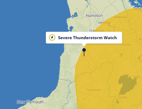
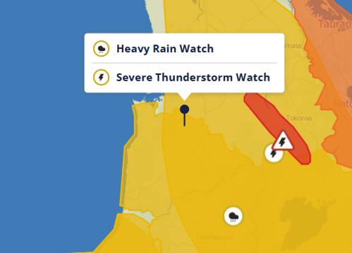
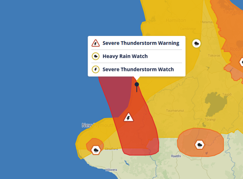
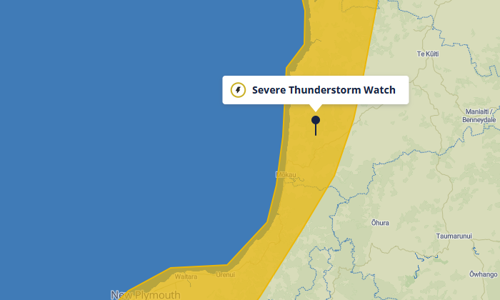
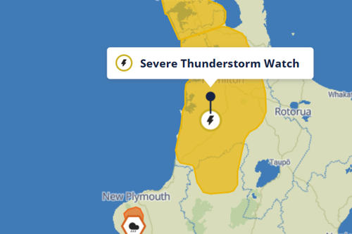
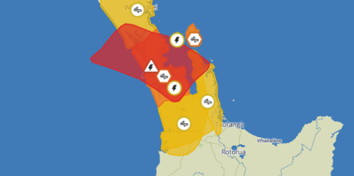
Severe Thunderstorm Watch
An active line of heavy showers and thunderstorms is expected to move across the upper North Island this afternoon and evening. There is a moderate risk that some of these thunderstorms may become SEVERE with rainfall intensities of 25 to 40 mm/h, hail 10 to 20mm in diameter and strong wind gusts about Auckland, Waikato and now extending down in to Waitomo and northern Taumarunui.
Rainfall of this intensity can cause surface and/or flash flooding, especially about low- lying areas such as streams, rivers or narrow valleys, and may also lead to slips. Driving conditions will also be hazardous with surface flooding and poor visibility in heavy rain. Large hail can cause significant damage to crops, orchards, vines, glasshouses and vehicles, as well as make driving conditions hazardous. Wind gusts of this strength can cause some structural damage, including trees and power lines, and may make driving hazardous.

19 April 2026 - 2.30pm
Update from NZTA - 2.30pm
SH3 between Mōkau and Piopio will remain CLOSED overnight and until further notice due to significant damage caused by heavy rainfall this weekend.
There are multiple large slips in the area, and crews are working hard to keep road users safe and clear the road as quickly as possible.
SH43 between Whangamomona and Taumarunui will also remain CLOSED overnight due to flooding.

Update at 12.30pm:
SH43 is closed again due to flooding. SH3 remains closed.
Update 8.55am - Weather warnings lifted, SH3 closed
All weather warnings for our district have been lifted. SH3 between Piopio and Mōkau remains closed. NZTA will provide an update when it is reopened.
SH43 is open.
https://www.journeys.nzta.govt.nz/highway-conditions/waikato
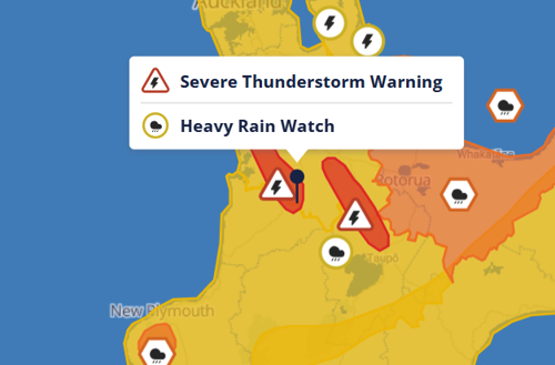
18 April 2026 - 9pm
🔴🔴 Severe Thunderstorm Warning
Metservice has issued a Red Severe Thunderstorm Warning for part of our district.
Area: Waitomo, Taupō, Ruapehu and Ōtorohanga
Forecast: At 08:37 pm, Metservice weather radar detected severe thunderstorms near Maniaiti/Benneydale, Waipa Valley and Mangapehi.
These thunderstorms are expected to be accompanied by very heavy rain.
Impact: Very heavy rain can cause surface and/or flash flooding about streams, gullies and urban areas, and make driving conditions extremely hazardous.
Please stay safe and keep informed.
You can phone us on 0800 932 4357 to report any issues.
The National Emergency Management Agency advises that as storms approach you should:
Take shelter, preferably indoors away from windows;
Avoid sheltering under trees, if outside;
Get back to land, if outdoors on the water;
Move cars under cover or away from trees;
Secure any loose objects around your property;
Check that drains and gutters are clear;
Be ready to slow down or stop, if driving.
During and after the storm, you should also:
Beware of fallen trees and power lines;
Avoid streams and drains as you may be swept away in flash flooding.

18 April 2026 - 6pm
SH3 closed due to flooding and rockfalls.
Due to flooding and rockfalls, SH3 between Piopio and Mōkau is closed.
There is no immediate detour through the area. Delay travel through the area or consider an alternative route for travel.
The road will remain CLOSED overnight, with an update due tomorrow morning, Sunday 19 April.
18 April 2026 - 5pm
Flooding and rockfalls on SH3
There are reports of flooding and rockfalls along SH3 at multiple locations between Mōkau and Piopio. Police and contractors are attending. Expect delays and exercise additional care along this route.
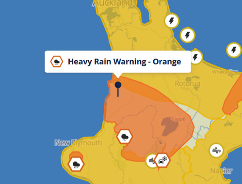
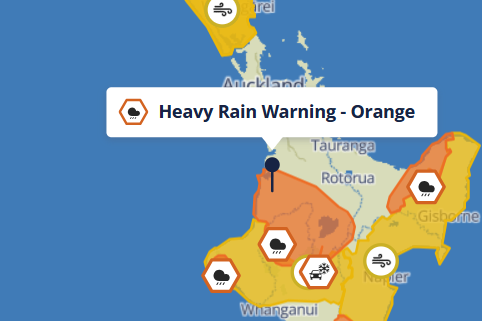
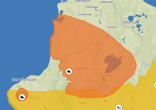
17 April 2026 - 10.30am
Heavy rain warning
🟠🟠 Stay inside this weekend and play some boardgames - a heavy rain warning has been issued for Waitomo District and Taranaki.
Good suggestions: Catan, Cluedo, Articulate, Ticket to Ride, Monopoly
Not so good suggestions: Risk
The details: The warning is valid for 18 hours from 10am Saturday 18 April to 9am Sunday 19 April.
Expect 80 to 110mm of rain, likely more about Taranaki Maunga. Peaks rates of 15 to 25 mm/h in possible thunderstorms.
The river levels are quite high currently and given the level of ground saturation there could be some impacts from this.
Rain of this intensity has the potential to cause surface or flash flooding. Do not attempt to swim, walk, or drive through flood waters and be sure to drive to conditions.
There is also a moderate risk of thunderstorms and a low risk that small tornadoes could form.
Stay inside. Avoid unnecessary travel. Strong winds can fell trees and poles, tear off roofs, and cause branches and debris to fly at high speed.

13 April 2026 - 10am
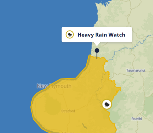
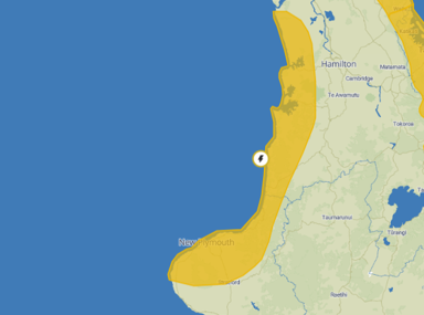
Heavy rain watch
The rain has returned and Metservice has issued a heavy rain watch for our district.
Period: 9am - 8pm Monday 13 April
Area: Northern Taranaki, Waitomo, Taumarunui, and Taupo west of the Lake
Forecast: Periods of heavy rain, with thunderstorms possible. Rainfall amounts may approach warning criteria in localised areas. Moderate chance of upgrading to a Warning.
Stay safe and drive to the conditions.

12 April 2026 - 9pm
Cyclone Vaianu passes through, watches and warnings lifted.
Metservice has lifted the heavy rain watch and strong wind warning for our district.
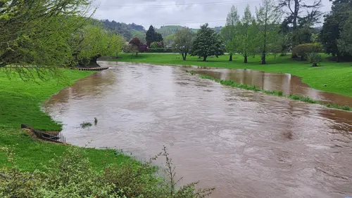
Impacts across the Western Waikato remain minor and localised, with no welfare needs identified. Response activity moves to a monitoring level now that the cyclone system has moved further east off the coast and some distance from our Western Waikato area. Te Whare Āhuru remains in a position to scale up at short notice. The EOC will continue to operate in a scaled-back structure with the ability to respond as needed.
A small number of issues are being managed, including a rural road closure, minor surface flooding, one isolated power outage, and rising river levels which remain below trigger thresholds. These are all under action incurring no significant risk. Monitoring will continue overnight.
The Waikato Civil Defence region-wide State of Emergency remains in place while warnings and watches continue to be monitored.
12 April 2026 - 2.50pm

We've got you covered! Emergency Operations Centre stood up for Western Waikato
A Western Waikato Emergency Operations Centre (EOC) is operating in Te Awamutu, supporting the Waipā, Waitomo and Ōtorohanga communities during Cyclone Vaianu.
The Centre, Te Whare Ᾱhuru, is coordinating the local Civil Defence response for Ōtorohanga District Council, Waipā District Council and Waitomo District Council, aligned with regional and national Civil Defence efforts.
Controller Dave Simes says the Centre is monitoring the cyclone’s progress across the North Island, with teams on standby to respond and provide support across the Western Waikato as needed.
As at 2.30pm 12 April, the districts have avoided the brunt of the cyclone so far, and support is being provided to the small number of affected locations.
12 April 2026 - 2.20pm
Please avoid unnecessary travel.
The heavy rain has set in and there is lots of surface water on our roads.
Please stay at home and do not venture out if travel is not necessary.
Stay safe:
🔸The combination of damaging winds, heavy rain and coastal inundation makes this a potentially life-threatening event.
🔸More rain falling on ground that’s already saturated, means impacts like fallen trees, landslides, flooding and dangerous river conditions are more likely.
🔸Put safety first. Don’t take any chances.
🔸During a storm, stay inside. Don't walk around outside. Don't drive unless necessary. Strong winds can fell trees and poles, tear off roofs, and cause branches and debris to fly at high speed.
🔸Act quickly if you see rising water. Floods and flash floods can happen quickly. If you see rising water, do not wait for official warnings. Head for higher ground and stay away from floodwater.
🔸Do not try to walk, play, swim, or drive in floodwater.
🔸If a landslide occurs – or you see any signs that the ground is unstable – evacuate immediately. Watch for warning signs like small slips or rockfalls, water flowing out of a slope, trees or fences that start to tilt or doors and window frames that start to stick.
🔸Don’t wait for emergency mobile alerts or other official warnings if you see flood waters rising or suspect that a landslide is about to occur – trust your danger sense and act immediately.
🔸Keep up to date with Metservice watches and warnings and follow the advice of Civil Defence group and emergency services.
12 April 2026 - 1.30pm
A strong wind warning remains in place for our district, and is valid until 3am on Monday 13 April.
A heavy rain watch is also in place, and is valid until 8pm this evening.
Avoid unnecessary travel during heavy rain or strong winds
Check on neighbours, especially those who may be elderly, isolated, or without reliable communications.
Put safety first
Keep up to date with Metservice watches and warnings and follow the advice of your local Civil Defence group and emergency services.
12 April 2026 - 9am
12 April 2026 - 8.30amA strong wind warning and heavy rain watch remains in place for our district, as Cyclone Vaianu tracks across the region.
Metservice, NEMA, Civil Defence Emergency Management Groups, NZDF, Police and FENZ have been activated in response to Cyclone Vaianu, with coordinated efforts underway across agencies and CDEM Groups.
If you are yet to feel the impacts of Vaianu, there is still time to prepare:
🔹Prepare for power cuts. Have torches ready and ensure you have access to a battery or solar-powered radio so you can stay up to date with the latest information and alerts.
🔹Check on neighbours, especially those who may be elderly, isolated, or without reliable communications.
🔸Put safety first
🔸Keep up to date with Metservice watches and warnings and follow the advice of your local Civil Defence group and emergency services.
12 April 2026 - 7am
Civil Defence activated in response to Cyclone Vaianu
Waitomo District Council 's Civil Defence team are in activation mode in response to Cyclone Vaianu, which has landed on the North Island today (Sunday 12 April) .
A Waikato regionwide State of Emergency has been declared and an Emergency Operations Centre stood up in Te Awamutu, covering Waitomo, Ōtorohanga and Waipā districts.
11 April 2026 - 1pm
Pre-emptive State of Emergency declared for Waikato Region
A pre-emptive Waikato regionwide State of Emergency has been declared today as Cyclone Vaianu approaches.
The move has been taken as a precaution given the potentially significant impacts that may be seen across the region from Cyclone Vaianu.
Declaring a State of Emergency allows the Civil Defence Controller access to emergency powers under the Civil Defence Emergency Management (CDEM) Act 2002.
The most commonly-used emergency powers include evacuating premises and places, entering premises, closing roads and public places, requisitioning property, equipment, material or supplies. Of these, enabling evacuations is often the key reason for an emergency declaration.
We don’t know yet whether emergency powers will need to be used, but this declaration means we can act quickly if required.
For Western Waikato Civil Defence (Ōtorohanga, Waipā and Waitomo districts) we are treating this as a heightened readiness situation. We are closely monitoring conditions across the district, particularly in areas where the ground is already saturated and more vulnerable to slips and flooding.
Please take the current warnings seriously.
Metservice warnings remain in place for our area:
Orange Strong Wind Warning (2am-10pm Sunday)
Yellow Heavy Rain Watch (8am-8pm Sunday)
These mean we are expecting hazardous winds and periods of heavy rain as the cyclone makes landfall and travels south over New Zealand.
What you should do now:
Stay up to date with official weather and emergency updates: www.metservice.com/warnings/home
Secure loose items around your property
Clear drains and gutters where it is safe to do so
Avoid unnecessary travel during heavy rain or strong winds
Check on neighbours, whānau, and those who may need extra support
Please stay alert, stay informed, and look out for each other. We will continue to provide updates as the situation develops.
11 April 2026 - 9am
![]()
Preparation underway as Cyclone Vaianu approaches
Waitomo District Council staff, our Civil Defence team and contractors are in preparation mode as Cyclone Vaianu approaches, predicting to hit the east coast of the North Island on Sunday.
While forecast details continue to evolve, experience shows the importance of early preparation and staying alert to changing conditions.
Behind the scenes, Emergency Management staff are monitoring forecasts, working with regional and national partners, and liaising with local contacts who provide valuable on-the-ground information. Council teams and contractors are carrying out pre-event checks and are on standby to respond if required.
Residents are encouraged to stay informed over the coming days, check forecasts regularly, and follow any safety advice issued by authorities.
10 April 2026
The Great NZ Muster is going ahead in Te Kūiti tomorrow (Saturday 11 April).
Information and advice from Metservice and Civil Defence indicates that Cyclone Vaianu is likely to land on the east coast of the North Island on Sunday morning.
Its exact track is still uncertain including the impact it may have on our district.
Safety and wellbeing is always at the top of our mind and our local Civil Defence team is working with Waikato Civil Defence, and are ready to respond.
We will continue to monitor the weather forecast and will keep you updated if there are changes to the weather system.
We acknowledge and appreciate your understanding.
10 April 2026 - 2.30pm
Prepare ahead for potential bad weather
With a weather warning in place for Sunday, our teams are out checking roadside drains and catchpits across town.
If you have drains on your property, please take a moment to check they’re not blocked.
Keeping private drains clear helps reduce surface flooding and protects our neighbours and township during heavy rain.
We are keeping a close eye on the weather forecast, and will update you when more information comes to hand.
10 April 2026 - 10am
Strong Wind Warning - Sunday 12 April
Metservice has issued a strong wind warning for our district and the majority of the North Island.
The period is from 10am to 10pm on Sunday 12 April.
A heavy rain watch is also still in place.
We are keeping a close eye on the weather forecast, and will update you about our decision on The Great NZ Muster later today 🐑🐑🐑
At this stage, the heavy weather is potentially not due to arrive until Sunday, well after our event. Safety and wellbeing is always at the top of our mind.
Details of the strong wind warning:
Area: Waikato, Waitomo, Taupo and Taumarunui
Forecast: Severe gale easterlies changing to severe gale westerly late afternoon or evening Sunday, gusting 120km/h in exposed places. Moderate chance of upgrading to a Red Warning.
Impact: Damage to trees, powerlines, and unsecured structures possible. Driving may be difficult, especially for high-sided vehicles and motorcycles.
Action: Prepare your property by securing items that can be picked up by strong winds. Drive cautiously.

9 April 2026 - 11.45am
Heavy Rain Watch and Strong Wind Watch
A heavy rain watch and strong wind watch has been issued for our district and the North Island.
Rain watch: From 8am - 8pm Sunday 12 April.
Area: Waitomo, Taumarunui, Taupo and Taranaki
Forecast: Periods of heavy rain, and amounts may approach warning criteria. Moderate chance of upgrading to a Warning.
Wind watch: From 4am Sunday 12 April to 1am Monday 13 April.
Western parts of the North Island, from Coromandel Peninsula to Wellington
Forecast: Easterly quarter winds turning west to southwesterly. Winds are likely to reach severe gale in exposed places and may be damaging. High chance of upgrading to a Warning.
Impact: Damage to trees, powerlines, and unsecured structures possible. Driving may be difficult, especially for high-sided vehicles and motorcycles.
Action: Prepare your property by securing items that can be picked up by strong winds. Drive cautiously.

9 April 2026
The Great NZ Muster and the weather forecast
Many of you will be wondering if The Great NZ Muster will still be going ahead given there is potential for wet and windy weather this weekend.
Council’s Civil Defence team are keeping a close eye on Cyclone Vaianu, which is predicted to hit parts of the North Island on Sunday.
Its exact track is still uncertain, and while there’s still uncertainty it is hard to make a call at this stage.
We will continue to monitor the weather forecast and will keep you updated as we know more. We will make a call closer to the weekend once we have an update from Metservice and Civil Defence.
We acknowledge and appreciate your understanding.
8 April 2026 - midday
Strong Wind Watch
A strong wind watch has been added to our heavy rain watch.
The rain watch is valid until 9pm this evening, and the wind watch is forecast from 1am to 11pm on Sunday 12 April.
Forecast: Cyclone Vaianu is likely to move across the North Island on Sunday, 12 April. If it does, it will bring damaging, potentially life-threatening winds. However, uncertainty remains in the cyclone's exact track, so the locations of the most severe winds are not yet certain. As confidence in the track increases, parts of this Watch will be upgraded to Orange or possibly Red Warnings. Vaianu will also bring heavy rain, with Heavy Rain Watches and/or Warnings likely to be issued on Thursday for some areas.
High chance of upgrading to a Warning.
Impact: Damage to trees, powerlines, and unsecured structures possible. Driving may be difficult, especially for high-sided vehicles and motorcycles.
Action: Prepare your property by securing items that can be picked up by strong winds. Drive cautiously.
8 April 2026
7 April 2026
Heads up - heavy rain watch for Wednesday.
Metservice has issued a heavy rain watch for our district from 3am to 6pm tomorrow (Wednesday 8 April).
Forecast: Periods of heavy rain, with localised downpours possible. Rainfall amounts may approach warning criteria. Thunderstorms possible Wednesday afternoon and evening. Moderate chance of upgrading to a Warning.
Take some time now to get prepared ahead of worst weather setting in.
Key preparedness tips:
🍂 Clear leaves and debris from gutters and drains to help reduce surface flooding
💦 If heavy rain and thunder does arrive, never walk, drive or play in flood water. Flood water can contain dangerous debris, missing manhole covers and the contained water can also make you sick.
Take care while out and about and drive carefully and to the conditions as there may be slips and landslides.
Helpful links to stay up to date:

29.3.2026
Heavy Rain watch
A heavy rain watch has been issued for our district and is valid from 1am to 8am tomorrow morning (Monday 30 March).
Metservice has indicated the most intense rainfall is expected within the Waitomo area. There is the possibility the Waitomo area could receive up to 50mm of rain accumulation across a 6 hour period between midnight and 6am, while most of the region may see up to 30mm of rain across the same timeframe.
Warning signs:
Small slips, rock falls, and sinking land, at the bottom of slopes.
Sticking doors and window frames, which may mean the land is slowly moving under the house.
Gaps where window frames are not fitting properly.
Steps, decks, and verandas, moving or tilting away from the rest of the house.
New cracks or bulges on the ground, road, footpath, retaining walls and other hard surfaces.
Tilting trees, retaining walls, or fences.
Water flowing out of a slope, like a new spring.
If you learn or suspect that a landslide is occurring, or is about to occur in your area, here’s what to do:
Move quickly out of its path and stay away from it. Evacuate immediately if it is safe to do so. Your best protection is higher ground outside the path of the landslide.
If you cannot leave safely, the side of your house furthest from the landslide is likely to be the safest location on your property.
Take your pets with you and move livestock to safe paddocks if you can do so without endangering yourself.
Alert your neighbours. They may not be aware of the potential hazard. It may save their lives. Help neighbours who need assistance to evacuate if you can do so without putting yourself in danger.
26 March 2026 - 10.30am
Heavy Rain Watch
Update: 8.45am Friday 27 March. Watch has been cancelled.
A heavy rain watch has been issued for our district.
The watch is valid all of today (Thursday 26 March) until 6pm Friday 27 March.
Metservice details:
Periods of heavy rain. Amounts may exceed warning criteria in localised areas, especially ranges. Moderate chance of upgrading to a Warning.
Take some time now to get prepared in case the weather gets worse.
Stay safe, drive safely and take care while out and about.
27 February 2026 - 4.30pm
Severe Thunderstorm Watch
⛈️🧐 Heads up, a severe thunderstorm watch has been issued for part of our district. The watch is valid from 4.30pm this afternoon to 11pm this evening.
🤞Fingers crossed nothing significant eventuates, but the weather can be very unpredictable.
Here are the details:
A showery unstable air mass is expected to affect the North Island from this afternoon and evening.
There is a moderate risk of severe thunderstorms with localised downpours bringing rainfall intensities of 25 to 40 mm/h. Rainfall of this intensity can cause surface and/or flash flooding, especially about low-lying areas such as streams, rivers or narrow valleys, and may also lead to slips.
Driving conditions will also be hazardous with surface flooding and poor visibility in heavy rain. There may also be slips and landslides.
Take some time now to get prepared ahead of worst weather setting in.
Key preparedness tips:
🍂 Clear leaves and debris from gutters and drains to help reduce surface flooding
💦 If heavy rain and thunder does arrive, never walk, drive or play in flood water. Flood water can contain dangerous debris, missing manhole covers and the contained water can also make you sick.
🏠Stay home for the night. Take advantage of a movie night or boardgame night - Maybe don't play 'Risk' though! 😆
Take care while out and about and drive carefully and to the conditions as there may be slips and landslides.
Helpful channels to stay up to date:
We'll share updates if anything changes.
13 February 2026 - 8pm
Please stay safe out there.
There is a lot of surface water flooding, so please drive carefully and to the conditions. And don't head out if you don't need to.
The heavy rain isn't due to ease until tomorrow morning.
- Stay out of the flood water, and stay away from streams and rivers
- Never walk, drive or play in flood water. Flood water can contain dangerous debris, missing manhole covers and the contained water can also make you sick.

13 February 2026
Severe Thunderstorm Warning
Alongside the heat and humidity, we are also expecting a severe thunderstorm ![]()
![]()
Take some time now to get prepared ahead of worst weather setting in.
Take care while out and about and drive safely and to the conditions.
12 February 2026
Update as at 11.30am on Friday 13 February: The watch for our district has been extended to 10am Saturday 14 February.
Heavy rain watch

23 January 2026
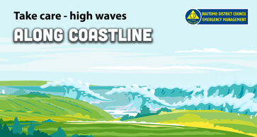
Take care – high wave warning along coastline
A high wave warning is in place for our coastline this weekend.
A strong westerly swell is expected from Saturday 24 January through to Sunday 25 January, with a swell event (high energy waves) and elevated water levels predicted.
This wave event is big, even for the west coast, with forecast swell over 5 metres and maximum wave height over 10 metres possible.
The highest risk period is within 1-2 hours of high tide.
The next high tide for the coastline from Marokopa to Mōkau is around 2pm on Saturday. For Sunday, high tide is around 2.50pm.
The potential for coastal erosion and inundation will present over high tide periods. Inundation levels with harbour areas close to the entrances may be close to king tide levels, but may include ‘surges’ that could raise water levels for short periods.
The wave event may exacerbate areas already prone to coastal erosion, such as Mōkau. Other areas along the west coast may also see erosion and inundation impacts.
Are you heading away for the long weekend? Or thinking about heading to the beach or going fishing?
We encourage you to stay away from the beach and coastline this weekend.
Coastal Inundation
With the high-wave warning, there is added risk of coastal inundation, which means flooding of low-lying areas along the coast.
Impacts include:
Damaged homes, businesses, and coastal infrastructure
Threatens coastal communities and ecosystems
Increases erosion as waves reach further inland
Take some time now to get prepared ahead of any potential impacts.
Key preparedness tips:
Secure outdoor furniture, trampolines and loose items if possible
Elevate appliances and valuable items
Never walk, drive or play in flood water. Flood water can contain dangerous debris, and can also make you sick.
Make a plan, think about where you would go if you needed to leave home quickly and how you will get there.
If you feel unsafe, evacuate to higher ground or away from coastal areas. You do not need to wait for an evacuation order to move to safety.
Help others if it is safe to do so, especially people who may require special assistance.
Helpful channels to stay up to date:
MetService warnings: https://www.metservice.com/warnings/home
WRC sea and river level data: https://www.waikatoregion.govt.nz/environment/envirohub/environmental-maps-and-data/?dt=Level
WRC coastal inundation tool: https://www.waikatoregion.govt.nz/services/regional-hazards-and-emergency-management/coastal-inundation-tool/
NZTA road conditions: https://www.journeys.nzta.govt.nz/highway-conditions
Council online service request form: https://www.waitomo.govt.nz/our-services/onlineservices/general-feedback/
Our Civil Defence team is actively monitoring the situation. We’ll share updates if anything changes.
Take extra care particularly when driving.
20 January 2026 - 4pm
20 January 2026 - 3pm
A large weather system associated with Tropical Low 14U is expected to move across parts of the country later this week.
15 Janaury 2026 - 5.30pm
15 January 2026 - 8.15am
It's a yellow day today. Metservice has issued a yellow heavy rain watch for our district, which is valid until 11pm this evening (Thursday 15 January).
Stay safe and drive to the conditions
--
)
-
 Metservice weather warnings
-
Local road network updates
-
Report an issue
-
Waitomo District Council Facebook
-
NZTA road conditions
-
Power outages
-
Waikato Civil Defence
-
Here to Help U
-
Waikato Region Flood Room
-
Environmental maps and data
-
WRC coastal inundation tool
-
Civil Defence Hazards
-
Planning for an emergency
)
Support is available
If need support, you can free text or call 1737 to speak to a counsellor, or call Healthline on 0800 611 116.
Ministry of Social Development (MSD)
Financial assistance, welfare support, accommodation help. Call 0800 559 009 or visit your local MSD office.
MSD community services information
Rural Support Trust
Confidential support for farmers and the rural community. Call 0800 787 254.
Link to website
Here to Help U
Get free social and wellbeing support the easy way. Submit a quick online request and we'll get you the right support.
Link to website
Call 0800 568 273 and leave a call back request
NZ Red Cross
Red Cross helps vulnerable people all around New Zealand — supporting them in times of disaster or emergency, delivering hot meals and other community services.
Visit the Red Cross website
NZ Police non-emergency online help
Use the online report option to make a non-emergency report, or you can call 105
Online 105 form
How you can help
Check on whānau, neighbours, and anyone who might need help
--

CIVIL DEFENCE UPDATES - 2025
28 December 2025
🌬️🌬️ A heads up that Metservice has issued a strong wind watch for our district for tomorrow 🌬️🌬️
The watch is valid from midday on Monday 29 December 2025 to 10pm that evening.
East to southeast winds may approach severe gale in exposed places. Moderate chance of upgrading to a Warning.
Action: Prepare your property by securing items that can be picked up by strong winds. Drive cautiously and take care while out and about.
--
22 December 2025 - Heavy rain watch
The lead up to Christmas isn't looking that great for parts of our district.
A yellow heavy rain watch is in place for the coastal areas of Waitomo district, and is valid from 11am Tuesday 23 December to 9am Wednesday 24 December.
Follow MetService New Zealand to stay up to date.
Keep safe and plan ahead.
2 December 2025 - 10.30am
👉👉Action:
Clear your drains and gutters to prepare for heavy rain. Avoid low-lying areas and drive cautiously.
👉👉 Handy links:
To report any slips or issues on our roads, please call 0800 932 4357 or use our online form:
https://www.waitomo.govt.nz/our-services/onlineservices/general-feedback/
Visit the get ready website for more info on how to prepare
https://getready.govt.nz/emergency/storms
👉👉 For updates:
Waikato Regional Council’s Flood Room Live for more information https://bit.ly/3CxAwmL
Metservice for weather information: https://www.metservice.com/warnings/home

This watch has been cancelled
The forecast is for periods of heavy rain with localised downpours and thunderstorms possible in the Mōkau area.
The watch is valid from 4am to 10am Friday 28 November.
Take care while out and about and drive to the conditions.
The weather warning has been lifted for our district.
The warning is valid until 6pm Wednesday 19 November. We're in for a wet day tomorrow.
Please take care if you are travelling tonight and tomorrow. There is a lot of surface water already on the roads. Surface flooding, slips, and difficult driving conditions are possible.
Stay away from rivers, streams and waterways as they could rise rapidly.
--
10 November 2025 - Pukerimu Road open
Pukerimu Road is now open to one lane.
The concrete barriers have been reinstated and we will continue to assess the road if there is heavy rain forecasted.
Safety and stability is a priority, and in the event of heavy rain, the road will likely close as there will be potential for further slips.
Thank you for your understanding.
28 October 2025 - Road closure
Pukerimu Road will be closed again to the public for safety reasons. The slip on Pukerimu Road is still moving and falling, making it unsafe for our roading team to continue clearing.
The closure will be in place until further notice. Thank you for your understanding.

--
Update: 9.10pm Monday 27 October 2025
On top of what has already fallen, expect 40 to 70 mm of rain, especially about the ranges. Thunderstorms possible. Peak rates of 15 to 25 mm/h expected Monday night and early Tuesday. May upgrade to a Red Warning.
Please drive to the conditions and be vigilant if needing to travel tonight. There is likely to be further slips on our already fragile roading network.
Warning is valid until 4am Tuesday 28 October 2025.
--
Update: 11am Monday 27 October 2025
Metservice has updated the timing of the orange heavy rain warning. It is now valid from 4pm today until 4am Tuesday 28 October 2025.
There will also likely be strong wind gusts of 90 to 110km/h. The combination of the rain and wind may likely cause additional slips.
Please drive to the conditions and be mindful if needing to travel this evening. There is likely to be further slips on our already fragile roading network.
--
26 October 2025
Orange Heavy Rain Warning
Metservice has issued an orange heavy rain warning for our district and is valid until 5am Tuesday morning 28 October.
We can expect 60 to 90 mm of rain, especially about the ranges. Thunderstorms possible. Peak rates of 15 to 25 mm/h expected Monday evening and overnight Monday. May upgradie to a Red Warning.
Streams and rivers may rise rapidly. Surface flooding, slips, and difficult driving conditions possible.
Please stay safe and stay at home if you don’t need to go anywhere.
Action:
Clear your drains and gutters to prepare for heavy rain. Avoid low-lying areas and drive cautiously.
How you can prepare:
If flooding is possible
- Be prepared to evacuate and keep your grab bag near
- Listen to emergency services and local Civil Defence authorities.
- Follow any instructions about evacuation of your area. Self-evacuate if you feel unsafe.
- Move pets to a safe place and move stock to higher ground.
- If you have to leave, take your pets with you. If it’s not safe for you, it’s not safe for them.
- Turn off water, electricity and gas if advised to.
- Move valuable and dangerous items as high above the floor as possible. This includes electrical equipment and chemicals.
- Use watertight containers to store important items.
- Lift curtains, rugs and bedding off the floor.
- Check on your neighbours and anyone who may need your help
What to do during a flood
- Put safety first. Don’t take any chances. Act quickly if you see rising water.
- Floods and flash floods can happen quickly. If you see rising water do not wait for official warnings. Head for higher ground and stay away from floodwater.
- Dial 111 if it is an emergency and lives are at risk.
Stay out of flood water
- Never try to walk, swim or drive through flood water. Many flood fatalities are caused by people attempting to drive through water. - - Always assume that flood water is contaminated with farm run-off, chemicals and sewage. Contaminated flood water can make you sick.
- Make sure you wash your hands, clothes and property after contact with flood waters.
To report any slips or issues on our roads, please call 0800 932 4357 or use our online form:
Visit the get ready website for more info on how to prepare
For updates:
Waikato Regional Council’s Flood Room Live for more information https://bit.ly/3CxAwmL
Metservice for weather information
--
12.30pm - Friday 24 October 2025
HEAVY RAIN ON THE WAY – please prepare and stay safe.
We have been advised that heavy rain is heading our way again on Monday and Tuesday.
At this stage Metservice has not issued any watches or warning for our District over the weekend. However, we are anticipating some heavy rain from 12pm Monday, 27 October to 12pm Tuesday, 28 October which may approach 70mm over this period.
The rain may be particularly heavy in the Marokopa / Awakino / Mōkau areas, so we would advise people to drive to the conditions, and if they are in low lying areas and close to rivers to keep an eye on the river levels.
How you can prepare:
What to do during a flood
Put safety first. Don’t take any chances. Act quickly if you see rising water. Floods and flash floods can happen quickly. If you see rising water do not wait for official warnings. Head for higher ground and stay away from floodwater. Dial 111 if it is an emergency and lives are at risk.
Stay out of flood water
Never try to walk, swim or drive through flood water. Many flood fatalities are caused by people attempting to drive through water. Always assume that flood water is contaminated with farm run-off, chemicals and sewage. Contaminated flood water can make you sick. Make sure you wash your hands, clothes and property after contact with flood waters.
If flooding is possible
Be prepared to evacuate and keep your grab bag near
Listen to emergency services and local Civil Defence authorities.
Follow any instructions about evacuation of your area. Self-evacuate if you feel unsafe.
Move pets to a safe place and move stock to higher ground.
If you have to leave, take your pets with you. If it’s not safe for you, it’s not safe for them.
Turn off water, electricity and gas if advised to.
Move valuable and dangerous items as high above the floor as possible. This includes electrical equipment and chemicals.
Use watertight containers to store important items.
Lift curtains, rugs and bedding off the floor.
Check on your neighbours and anyone who may need your help
Keep informed by following Metservice
--
Roading updates as at 8am, Thursday 23 October 2025
The following roads remain CLOSED:
Kopaki – Landslides
Mokauiti - Underslip
The rest of the roads affected by last week's weather are open to at least one lane.
--
Roading updates as at 10am, Tuesday 21 October 2025
The following roads remain CLOSED:
Kopaki – Landslides
Mangatoa - Slip
Mokauiti - Underslip
Pomarangai – Slip
Pukerimu – Trees and slip
The rest of the roads affected by last week's weather are open to at least one lane.
--
Roading updates as at 10am, Monday 20 October 2025
CLOSED ROADS:
Kopaki – Landslides
Mangatoa - Slip
Mokauiti - Underslip
Pomarangai – Slip
Pukerimu – Trees and slip
Tawarau - Slip
Waikawau- Slips
ROADS NOW OPEN:
Aria
Mangaokewa
Kaitaringa
Kohua
Marokopa
Ohura
Tumutumu
Waitanguru
ROADS OPEN TO ONE LANE
Gribbon – Slips and slump
Hauturu – Slips
Kawhia Harbour - Slip and flooding
Mangaiti – Slip
Manganui – Overslips
Mangaokewa North – Slips
Mangaotaki – Slips and flooding
McBeths – Slip
Papakauri – Slip
Ramaroa - Underslip
Taumatamaire – Flooding
Te Anga – Slips, flooding, trees
Te Mahoe - Slip
Te Waitere – Underslips
Tikitiki - Slips
Totoro – Underslips
Waipuna - Slip
Waitomo Valley – Flooding
Waimiha - Slip
Whakapirau - Trees
--
Roading updates as at 10am, Saturday 18 October 2025
CLOSED ROADS:
Kohua - Slips and flooding
Kopaki – Landslides
Mangatoa - Slip
Mokauiti - Underslip
Pomarangai – Slip
Pukerimu – Trees and slip
Tawarau - Slip
Waikawau- Slips
Tikitiki - Slips
ROADS NOW OPEN:
Aria
Mangaokewa
Kaitaringa
Marokopa
Tumutumu
Waitanguru
ROADS OPEN TO ONE LANE
Gribbon – Slips and slump
Hauturu – Slips
Kawhia Harbour - Slip and flooding
Mangaiti – Slip
Manganui – Overslips
Mangaokewa North – Slips
Mangaotaki – Slips and flooding
McBeths – Slip
Ohura - Slips and flooding
Papakauri – Slip
Ramaroa - Underslip
Taumatamaire – Flooding
Te Anga – Slips, flooding, trees
Te Mahoe - Slip
Te Waitere – Underslips
Totoro – Underslips
Waipuna - Slip
Waitomo Valley – Flooding
Waimiha - Slip
Whakapirau - Trees
8.30am, Friday 17 October 2025
The road to recovery will likely take years and cost millions of dollars, as Waitomo District residents are still feeling the impact of the extensive flooding event that hit earlier this week.
While parts of the district still remain under water, General Manager Strategy and Environment and local Civil Defence Controller, Alex Bell says it will take quite some time to fully realise the extent of the damage across the district.
“There are many residents who are still coming to terms with the impact of the flooding. And because there are still areas blocked off and inaccessible, it is hard to determine the level of damage our district has suffered.
Waitomo District Council and roading contractors Inframax Construction Ltd and Pinnacles Civil will be busy over the next few weeks undertaking assessments of damage to roads, bridges and other infrastructure.
--
Roading updates as at 4.45pm, Thursday 16 October 2025
CLOSED ROADS:
Manganui – Slips and flooding
Tawarau - Slip
Waipuna - Slip
Ohura - Slips and flooding
Pukerimu – Trees and slip
Hauturu - Slips
Kaitaringa - Flooding
Kohua - Slips and flooding
Mangatoa - Slip
Kopaki – Landslides
Pomarangai – Slip
Waitanguru – Washout
Mokauiti - Closed between Mangateka to SH4
ROADS NOW OPEN:
Aria
Tumutumu
Mangaokewa
ROADS OPEN TO ONE LANE
McBeths - Slip
Taumatamaire – Flooding
Papakauri – Slip
Mangaiti – Slip
Kawhia Harbour - Slip and flooding
Te Anga – Slips, flooding, trees
Troopers - Trees
Te Mahoe - Slip
Gribbon – Slips and slump
Waitomo Valley – Flooding
Marokopa – Flooding
Mangaotaki – Slips and flooding
Whakapirau - TreesWaimiha - Flooding
Waimiha-Poro-o-Tarao (Ruapehu) - Slips and flooding
--
Update from NZTA as at 2.45pm
Crews have been working hard to clear slips and repair damage caused by heavy rainfall and high floodwater levels. NZTA are monitoring the roads closely and ask that road users continue to delay travel unless absolutely necessary.
SH3 Awakino between Mōkau and Piopio is expected to be OPEN from 3pm Friday 17 October under stop/go traffic controls:
• There will be multiple sites under stop/go traffic controls on SH3 between Tongapōrutu and Piopio over the coming weeks.
• Road users should plan ahead for additional travel times of approximately 40-60 minutes in this area.
• Please keep an eye out for our crews and drive to the conditions.
The below areas are expected to remain CLOSED until 8pm Friday 17 October:
• SH4 between SH3 and SH43.
• SH43 between Taumarunui and Whangamomona.
--
Roading updates as at 1.30pm, Thursday 16 October 2025
ROADS NOW OPEN:
Aria
Tumutumu
Mangaokewa
Marokopa – open to one lane
Mangaotaki - open to one lane
CLOSED ROADS:
McBeths - Slip
Pomarangai - Slip
Manganui – Slips and flooding
Whakapirau - Trees
Tawarau - Slip
Waipuna - Slip
Mangaiti – Slip
Ohura - Slips and flooding
Pukerimu – Trees and slip
Hauturu - Slips
Kaitaringa - Flooding
Kohua - Slips and flooding
Waimiha-Poro-o-Tarao (Ruapehu) - Slips and flooding
Waimiha - Flooding
Mangatoa - Slip
Kopaki – Washout
ROADS OPEN TO ONE LANE
Waitanguru - please take caution, only light vehicles
Taumatamaire – Flooding
Papakauri - Slip
Kawhia Harbour - Slip and flooding
Te Anga – Slips, flooding, trees
Troopers - Trees
Te Mahoe - Slip
Gribbon – Slips and slump
Waitomo Valley – Flooding
Marokopa – open to one lane
Mangaotaki - open to one lane
STATE HIGHWAYS
The following areas are expected to remain CLOSED until 8pm Friday 17 October:
SH3 Awakino between Mōkau and Piopio
SH4 between SH3 and SH43
--
Roading updates as at 7pm, Wednesday 15 October 2025
CLOSED ROADS:
Tumutumu – Flooding
Mangaokewa Road – Slip and flooding
Marokopa – Flooding
Manganui – Slips and flooding
Aria – Flooding
Mangaiti – Slip
Ohura - Slips and flooding
Pukerimu – Trees and slip
Mangaotaki - Slips and flooding
Hauturu - Slips
Kaitaringa - Flooding
Kohua - Slips and flooding
Waimiha-Poro-o-Tarao (Ruapehu) - Slips and flooding
Waimiha - Flooding
Mangatoa - Slip
Kopaki – Washout
Whakapirau - Trees
Tawarau - Slip
Waipuna - Slip
ROADS OPEN TO ONE LANE
Taumatamaire – Flooding
Papakauri - Slip
Kawhia Harbour - Slip and flooding
Te Anga – Slips, flooding, trees
Troopers - Trees
Te Mahoe - Slip
Gribbon – Slips and slump
Waitomo Valley - Flooding
STATE HIGHWAYS:
The following areas are expected to remain CLOSED until 8pm Friday 17 October:
SH3 Awakino between Mōkau and Piopio
SH4 between SH3 and SH43
--
SH30 Update - on behalf of NZTA as at 4.20pm
Crews have been working to clear slips following heavy rain and flooding. State Highway (SH30) from Te Kūiti to Maniaiti/Benneydale is expected to open by 7pm tonight Wednesday 15 October.
There will be two one-lane sections with priority give-way control.
--
12pm Wednesday 15 October 2025
Targa Rally has confirmed the SS15 and SS16 rally that was scheduled to come through our district on Thursday has been cancelled.
--
Roading updates as at 11.15am, Wednesday 15 October 2025
Crews are working hard to clear slips and flooding where possible
SH3 Awakino between Mōkau and Piopio and SH4 between SH3 and SH43 will remain CLOSED to all traffic until Thursday morning, 16 October.
Due to high water levels, crews are unable to clear the roads until the flooding subsides.
CLOSED ROADS:
Tumutumu – Flooding
Mangaokewa Road – Slip and flooding
Marokopa – Flooding
Aria – Flooding
Mangaiti – Slip
Ohura - Slips and flooding
Pukerimu – Trees and slip
Mangaotaki - Slips and flooding
Manganui – Slips and flooding
Hauturu - Slips
Kaitaringa - Flooding
Kohua - Slips and flooding
Waimiha-Poro-o-Tarao (Ruapehu) - Slips and flooding
Waimiha - Flooding
Mangatoa - Slip
Kopaki – Washout
Tuhua - Flooding
ROADS OPEN TO ONE LANE
Taumatamaire – Flooding
Papakauri - Slip
Kawhia Harbour - Slip and flooding
Te Anga – Slips, flooding, trees
Troopers - Trees
Te Mahoe - Slip
Gribbon – Slips and slump
Waitomo Valley - Flooding
OPEN ROADS
Te Kumi Station - Flooding
Eketone Street - Flooding
Edward Street - Flooding
Esplanade North – Flooding


--
10.30am, Wednesday 15 October 2025
Road users breaching closed areas
We are receiving reports of the general public and residents ignoring road closures and trying to travel through closed areas.
There is still lots of slips, and flooding on many roads in our district.
There is also heavy machinery, including the slip sites which are blocking both lanes on SH30 between Kopaki and Maniaiti/Benneydale.
Road users are not adhering to the road closures and are ignoring staff. Not only is this dangerous, but it puts our roading crews at risk. Please do not do this.
We are working with our roading contractors on getting an updated list of road closures and will share this as soon as possible.
Thank you for your understanding.
---
Update as at 8.20pm, Tuesday 14 October 2025
Update: Mangaokewa Stream and flooded areas
Update as at 2.30pm:
Metservice has removed the weather warning for our district.
--
As at 1.45pm, Tuesday 14 October 2025
The following roads remain CLOSED due to flooding and slips across the state highway network:
• SH3 Awakino between Mōkau and Piopio
• SH4 between SH3 and SH43
Due to rising water levels, crews are unable to clear the roads until the flooding subsides.
Please be patient while we endeavour to handle your enquiries.
Alternatively, you can email us at [email protected] or report an issue via our website form.
https://www.waitomo.govt.nz/our-services/onlineservices/general-feedback/
--
Waimiha - Flooding
Waimiha-Poro-o-Tarao Rd (Ruapehu District) Slips and flooding
Kohua - Slips and flooding
Kaitaringa - Flooding
Gribbon - Flooding
Hauturu - Slips
Mangaotaki - Slips and flooding
Ohura - Flooding
Due to numerous flooding, slips and road closures, we are unable to pick up kerbside collection in parts of our district, including Tumutumu Road, Marokopa, Kinohaku, Te Anga, and Maniaiti/Benneydale.
We apologise for the inconvenience.
Aria - Flooding
Marokopa - Flooding
Te Anga - Slips and flooding
Kawhia Harbour - Slips and flooding
Papakauri - Slip
Ohura - Flooding
Mangaiti - Slip
Mangaokewa - Slips and flooding
Manganui - Slips and flooding
Taumatamaire - Slips and flooding
Tumutumu - Flooding
Other impacted roads:
Gribbon - slips cleared
Te Mahoe - slip still to be cleared
Pukerimu - Tree down. Cut and moved to shoulder. Still to be cleared
Troopers/Whataroa - Tree down. Cut and moved to shoulder. Still to be cleared
--
WEATHER UPDATES - ROADING
SH3 Awakino between Mōkau and Piopio
SH4 between SH3 and SH43
SH30 between Te Kūiti and Maniaiti/Benneydale
With SH4 between Eight Mile Junction and Taumarunui closed and SH3 between Mōkau and Piopio also closed, road users are urged to travel inland (from Waimarino National Park to Taupō).
14 October 2025
Mangaokewa Stream levels in Te Kūiti are high. Please stay away from the riverbank for safety.
SH3 between Mōkau and Piopio is CLOSED due to multiple slips
Due to flooding in the area, SH30 will be CLOSED between Kopaki Rd and Ohirea Rd. Consider delaying your journey and allow extra time.
There's lots of slips, trees down and flooding around the district
We're expecting more rain today so please stay safe and drive to the conditions
Take it slow on the roads and allow extra travel time
Steer clear of low-lying areas
Keep an eye on MetService New Zealand for updates
Keep up to date by following our FB page
--
23 September 2025
The northern part of our district has been included in a heavy rain watch for the Waikato region.
The watch is valid from 2pm this afternoon to 1pm tomorrow (Wednesday 24 September).
There will likely be periods of heavy rain, with localised downpours possible.
We will keep you updated about whether our upcoming events will be affected by the weather.
Visit Metservice to keep up to date with the weather forecast.
--
13 September 2025
A severe thunderstorm watch is currently in place for our district and is valid until 5pm this evening (Saturday 13 September).
Stay safe while out and about and keep up to date through Metservice.

--
31 August 2025
The weather is not great today and a strong wind watch is in place for our district.
⌚️ Valid from 3pm to 9pm today (Sunday 31 August 2025)
📍 Waitomo District
💨 Southwest winds may approach severe gale in exposed places. Moderate chance of upgrading to a Warning.
Stay safe while out and about.
Follow metservice to stay update
https://www.metservice.com/warnings/home
--
28 July 2025
❄️Despite the frosty mornings, it has been so lovely seeing the sunshine over the past week! 🌞
Looks like wet weather is coming our way again though 🙃 Metservice has issued a heavy rain watch for our district, which is due around 4am Tuesday 29 July to 4am Wednesday 30 July.
Take care and enjoy the sun before the rain takes over.
Tips to prepare:
🍂Clear your drains and gutters to prepare for heavy rain
🚗Drive to the conditions
Get all of the details, and keep up-to-date here: www.metservice.com/warnings/home
--
11 July 2025 - 1pm
With the ground already saturated, it won't take much rain to bring localised surface flooding again.
Waikato Regional Council’s Flood Room Live for more information
Metservice for weather information
--
10 July 2025 - 1pm
Heavy Rain Watch ![]()
Get all of the details, and keep up-to-date here: www.metservice.com/warnings/home
--
3 July 2025 - 8.20pm
--
3 July 2025 - 7.30pm
--
3 July 2025 - 7pm
![]() AWAKINO GORGE CLOSED
AWAKINO GORGE CLOSED ![]()
Alternatively, you can visit www.nzta.govt.nz/contact-us.
In the event of an emergency please dial 111.
--
3 July 2025 - 5.15pm
![]() PLEASE DRIVE SAFE THROUGH AWAKINO GORGE
PLEASE DRIVE SAFE THROUGH AWAKINO GORGE ![]()
Please do not undertake any unnecessary travel, but drive safely and to the conditions if you have to.
Some great advice from the Get Ready website about what to do during a storm:
Stay inside. Don't walk around outside. Don't drive unless absolutely necessary.
Close exterior and interior doors and windows. Pull curtains and blinds over windows. This could prevent injury from flying glass if the window breaks.
Stay informed during an emergency. Listen to the radio or follow your Civil Defence Emergency Management Group online.
Follow the instructions of civil defence and emergency services.
Avoid bathtubs, water taps, and sinks. Metal pipes and plumbing can conduct electricity if struck by lightning. Use your water from your emergency supplies.
Unplug small appliances that may be affected by electrical power surges. If you lose power, unplug major appliances. This will reduce the power surge and possible damage when power is restored.
For more info, visit Get Ready
--
3 July 2025 - 4.45pm
Waikato Regional Council’s Flood Room Live for more information
Metservice for weather information
--
3 July 2025
![]()
![]()
![]() Metservice update
Metservice update ![]()
![]()
![]()
Waikato Regional Council’s Flood Room Live for more information
Metservice for weather information
--
2 July 2025
Heads up Waitomo, heavy rain is coming our way
Metservice has issued a heavy rain watch for the Waikato region, including Waitomo and valid from midday to midnight on Thursday 3 July.
Area: Waikato, Waitomo, Taumarunui, Taupo and North Taranaki
Forecast: Periods of heavy rain with localised downpours, and amounts may approach warning criteria. Moderate chance of upgrading to a Warning.
Get winter ready: Clear your drains and gutters to prepare for heavy rain. Avoid low-lying areas and drive cautiously.
For updates:
Waikato Regional Council’s Flood Room Live for more information
Metservice for weather information:
--
10 June 2025 - 10am
--
5 June 2025 - 6.20M
--
4 June 2025 - 6.30pm
It is very wet and slippery on our roads tonight due to surface water. Metservice is predicting the heavy rain will likely get worse later tonight.
Please drive safely and to the conditions.
--
4 June 2025 - 10.30am
A heads up - Metservice has issued a heavy rain watch for our district. It is valid from midday today (Wednesday 4 June) to 3am tomorrow morning.
Periods of heavy rain with localised downpours and thunderstorms possible. Rainfall accumulations may approach warning criteria in some places. Rain easing from the west this evening.
Moderate chance of upgrading to a Warning.
Stay safe and take care while out and about.
--
26 May 2025 - 10am
MetService has issued a severe thunderstorm watch for part of the Waitomo district. The watch is valid until 6am on Tuesday 27 May 2025.
A front is expected to bring rain and a low risk of thunderstorms to western parts of the North Island from Taranaki northwards from this evening until around dawn Tuesday.
Stay safe while out and about.
--
18 May 2025 - 9am
Metservice has issued a heavy rain watch for our district, and the Taranaki and Waikato areas.
The watch is valid from midday until 11pm today (Sunday 18 May 2025)
Area: Northern Taranaki, Taumarunui, Waitomo, Waikato south of Raglan, Tongariro National Park, and Taupo west of the Lake
Forecast: A period of heavy rain, and amounts may approach warning criteria. Rain easing from the west Sunday evening.
Moderate chance of upgrading to a Warning.
--
8 May 2025 - 10.30am
The Coldplay song "Yellow" comes to mind when looking at the Metservice information for the next few days.
"And it was all yellow!"
This means Metservice has a issued a heavy rain watch for our district and is valid until 10pm tomorrow, Friday 9 May.
The details and what could eventuate:
Periods of heavy rain, with thunderstorms possible. Rainfall amounts may approach warning criteria and possibly exceed them about isolated areas, especially in localised downpours. High chance of upgrading to a Warning.
Potential impact: Streams and rivers may rise rapidly. Surface flooding, slips, and difficult driving conditions possible.
Actions to take to prepare: Clear your drains and gutters to prepare for heavy rain. Avoid low-lying areas and drive cautiously.
As always, stay safe while out and about.
--
20 April 2025
Metservice has issued a Severe Thunderstorm watch for our district, valid from 1pm to 10pm today (Easter Sunday).
A few of the thunderstorms could be severe, with localised rainfall rates of 25-50mm/h. Rainfall of this intensity can cause surface and/or flash flooding, especially about low-lying areas such as streams, rivers or narrow valleys, and may also lead to slips.
Driving conditions will also be hazardous with surface flooding and poor visibility in heavy rain. The thunderstorms activity should die away late evening.
As always, stay safe and drive to the conditions if out and about.
--
15 April 2025
Metservice has issued a strong wind watch for our district from midnight Wednesday
The watch is valid from 12am Wednesday 16 April to 3am on Friday 18 April.
Damage to trees, powerlines, and unsecured structures possible. Driving may be difficult, especially for high-sided vehicles and motorcycles.
--
4 April 2025
The current Heavy Rain Watch has been extended to 8pm, Friday 4 April 2025.
--
2 April 2025
Metservice has issued a heavy rain watch for our district for this Friday. It is just a 'watch' at this stage, and is valid from 3am to 4pm on Friday 4 April.
Periods of heavy rain, and amounts may approach warning criteria. Moderate chance of upgrading to a warning.
--
11 February 2025
Glad to see the rain!
Stay safe while out and about.
--
10 February 2025
Nothing to be too alarmed about hopefully, but Metservice has issued a severe thunderstorm watch for the central North Island, and a tiny part of our district might be impacted.
The watch is valid from 3pm to 10pm today.

--
7 February 2025
Small update to the severe thunderstorm watch currently in place for parts of our district.
The watch is valid from 2pm-8pm today (Friday 7 February 2025).
As always, stay safe and follow MetService New Zealand to stay up to date.

--
6 February 2025
Metservice has issued a severe thunderstorm watch for our district for Friday 7 February 2025. The watch is valid from 2pm to 9pm.
Stay safe and follow metservice to stay up to date.
--
2 February 2025
A Severe Thunderstorm Watch is in place for Waitomo District this evening.
Stay safe while out and about tonight.
--
CIVIL DEFENCE UPDATES - 2024
26 December 2024 - 11am
Severe Thunderstorm Watch
Metservice has issued a severe thunderstorm watch for the Waitomo District and the greater Waikato region. The watch is valid from 1pm to 9pm tonight.
Scattered thunderstorms are expected about parts of the northern half of the North Island today, with localised heavy rain and hail. For Waikato, Waitomo, Coromandel Peninsula (south of about Whitianga) and western parts of Bay of Plenty and Rotorua (from about Whakatane westwards), a few of the thunderstorms may be severe between 1pm and 9pm today (Boxing Day) with localised downpours of 25-40mm/h (or possibly more). Rainfall of this intensity can cause surface and/or flash flooding, especially about low-lying areas such as streams, rivers or narrow valleys, and may also lead to slips. Driving conditions will also be hazardous with surface flooding and poor visibility in heavy rain. The thunderstorms activity should ease this evening.
Please take care while out and about.
--
14 November 2024 - 1.30pm
Metservice has issued a Heavy Rain Watch for Northern Taranaki, and Waitomo.
The watch is valid from 6am to 6pm tomorrow (Friday 15 November). Heavy rain, and amounts may approach warning criteria. Rain easing from the west during Friday afternoon. Moderate chance of upgrading to a warning.
Take care while out and about.
--
7 October 2024 - 7am
We currently have a heavy rain watch in place for our district and the greater Waikato.
Watch is valid until 1pm today. Please drive safely and to the conditions if out and about today.
--
2 October 2024 - 9pm
Metservice has issued a heavy rain watch for the Waitomo district, and greater Waikato area.
The watch is valid from 10pm tonight (2 October) until 10am, Thursday 3 October.
Please stay safe and drive to the conditions if you need to travel during this time.
Stay up to date with weather information by visiting the Metservice website.
--
22 September 2024
Metservice has issued a severe thunderstorm watch for Waitomo Taumarunui, Taranaki, Taihape, and Wanganui this afternoon. Heavy rain, hail, squally wind gusts and frequent lightning.
Please take care while out and about.
--
13 September 2024
Heavy rain watch
Metservice has issued a heavy rain watch for the Waitomo district. The watch is valid from midnight Friday 13 September to midnight Saturday 14 September. Periods of heavy rain, and amounts may approach warning criteria. Moderate chance of upgrading to a Warning. Please take care while out and about.
--
31 August 2024
Severe Thunderstorm watch
An active front is forecast to move over the North Island during Sunday morning, with thunderstorms forecast for many North Island regions including Waitomo. There is a particular risk of the thunderstorms being most severe in the Waitomo district from Midnight Saturday to 7am Sunday 1 September.
Rainfall of this intensity can cause surface and/or flash flooding, especially about low-lying areas such as streams, rivers or narrow valleys, and may also lead to slips. Driving conditions will also be hazardous with surface flooding and poor visibility in heavy rain.
Some of these thunderstorms may also be squally, and produce damaging wind gusts of 110 km/h or stronger. Wind gusts of this strength can cause some structural damage, including trees and power lines, and may make driving hazardous.
Please take extra caution if you are travelling during this time. Stay safe.

--
30 August 2024
Metservice has issued a heavy rain watch for our district, valid from 6pm Saturday 31 August to 5am Sunday 1 September.
A period of heavy rain, and amounts may approach warning criteria.
Please stay safe while out and about.
There is a moderate chance that this watch will be upgraded to a warning, or that the weather watch could be extended to Sunday afternoon.
Please take care if you plan to travel during this time.
An intense line of thunderstorms is expected to move slowly east across the north of Taranaki east of New Plymouth and coastal Waitomo.
These storms could bring localised downpours with rainfall rates of 25 to 40 mm/h. Rainfall of this intensity can cause surface and/or flash flooding, especially about low-lying areas such as streams, rivers or narrow valleys, and may also lead to slips.
Driving conditions will also be hazardous with surface flooding and poor visibility in heavy rain.
Please take care while out about about today.
Weather Watch - Heavy Rain
Please take care while out and about tomorrow.

Metservice has issued a Severe Thunderstorm Watch for the western parts of Waikato and Waitomo.
There is also an alert for the potential of a few small tornadoes along the coastline of our district early tomorrow morning.
The watch is valid until 6am tomorrow morning (Thursday 16 May).
A low with an associated band of rain and possible thunderstorms is expected to move onto the western North Island early on Thursday morning. Within this band of rain and thunderstorms, there is a moderate risk of a few small or damaging tornadoes about western parts of Waikato, Waitomo and North Taranaki, mainly near the coast, between about 1am and 6am Thursday morning.
The tornadoes could occur with or without thunderstorms, and if they do occur they are expected to be very localised and short-lived, but could cause damage to structures and vegetation.
Note: A Severe Thunderstorm Watch means conditions are favourable for severe thunderstorms in and close to the watch area. People in these areas should be on the lookout for threatening weather conditions and monitor for possible Severe Thunderstorm Warnings.
For information on preparing for and keeping safe during a storm, see the Civil Defence Get Ready website
A front will move eastwards over the North Island during today, bringing a period of heavy rain. There is mostly a low to moderate risk of thunderstorms with the frontal rain as it moves over the north of the North Island.
Weather watch: Heavy rain, strong wind and severe thunderstorms
Please take care while out and about today.
Weather Update: The current heavy rain warning has been upgraded to orange and is valid until midnight tonight.
Please take care while out and about, and consider not travelling if you don't need to.
CIVIL DEFENCE UPDATES - 2023
--
27 October 2023 - 5pm
PREPARE FOR POTENTIAL BAD WEATHER – TROPICAL CYCLONE LOLA
There is a very real possibility that our district will be impacted by Tropical Cyclone Lola.
Predictions are that the cyclone will bring prolonged heavy rainfall, high winds and high tides. Indications are that this will start taking place on Sunday evening, with the biggest impact being on Monday and Tuesday next week.
At this stage this is all the information we know, but we will keep you updated when more information comes to hand. Fingers crossed nothing comes to fruition!
Our amazing Civil Defence team is monitoring the situation, and in the meantime, we encourage you to prepare as much as you can and keep up to date with MetService weather forecasts.
The Get Ready website has information about hazards in New Zealand and advice about how to get prepared for an emergency.
https://getready.govt.nz/en/prepared/household/
https://getready.govt.nz/en/emergency/storms/
Work out what supplies you might need and make a plan. Have materials and tools ready to repair windows, such as tarpaulins, boards and duct tape.
Identify a safe place in your home to gather during a thunderstorm. This should be a place where there are no windows, skylights, or glass doors. These could break in strong winds or hail and cause damage or injury.
Know which paddocks are safe if you have livestock. To prevent risks from lightning, move livestock away from:
floodwaters
landslides
power lines, and
isolated trees.
Be aware that storms can trigger floods and landslides. Make sure you know how to respond.
Stay safe and take care
--
8 October 2023 - 6.30pm
--
8 October 2023 - 12.30pm
WEATHER WATCH - Severe Thunderstorm
26 September 2023 - 3pm
--
23 September 2023 - 4pm
--
22 September 2023 - 2.55pm
WEATHER WATCH - Heavy Rain
Please take care and drive to the conditions while out and about this weekend.
--
18 August 2023 - 10.15am
WEATHER WATCH - Heavy rainfall
MetService has issued a heavy rainfall watch that includes Waitomo District. It is valid from 8pm Saturday night until 6pm Sunday.
A period of heavy northerly rain, accumulations may approach warning criteria.
Severe gales are also forecast across much of the North Island on Monday.
Please take care and drive to the conditions while out and about this weekend.
A strong wind watch is currently in place for the Waitomo District and is valid until 3am tomorrow morning.
For more information, please check out Waikato Regional Council's Floodroom Live
19 May 2023 - 6.45pm
TSUNAMI ACTIVITY – EXPECT STRONG AND UNUSUAL CURRENTS AND UNPREDICTABLE SURGES AT THE SHORE
We expect New Zealand coastal areas to experience strong and unusual currents and unpredictable surges at the shore following a magnitude 7.7 earthquake SOUTHEAST OF LOYALTY ISLANDS at 2023-05-19 3:57 PM.
This National Advisory has been issued following an assessment of information available. The situation may change as new information becomes available. Listen to the radio or TV for updates, or check www.civildefence.govt.nz
--
3 May 2023 - 8.55pm
HEAVY RAIN WARNING - Waitomo
Valid from 8pm Wednesday, 3 May - 6pm Thursday 4 May.
A heavy rain warning has been issued for Waitomo. Expect 90 to 130 mm of rain, mainly west of Te Kūiti. Peak rates of 15 to 25 mm/h or possibly more. Heavy rain may cause streams and rivers to rise rapidly. Surface flooding and slips are also possible and driving conditions may be hazardous.
Please take care while driving on our roads.
--
11 April 2023
--
27 February 2023 - 1.15pm
WEATHER WATCH - Severe Thunderstorm Watch
For information on preparing for and keeping safe during a storm, see the Civil Defence Get Ready website
--
15 February 2023 - 10.26am
Roading Update:
There are a few blocked roads in our district due to fallen trees.
We are working on clearing these as soon as possible.
14 February 2023 - 10.10am
Roading update:
Cyclone Gabrielle has only toppled a couple of trees on Kopaki Road and Te Anga Road overnight.
These have since been cleared and the roads are open.
--
14 February 2023 - 9.20am
NATIONAL STATE OF EMERGENCY DECLARED
Click here to read the full Media Release
--
14 February 2023 - 9.10am
Our country has now moved into a National State of Emergency
PLEASE STAY SAFE!!
If your life, health or property is in danger, call 111 immediately.
Keep up to date with MetService weather forecasts.
Follow the advice of Civil Defence and emergency services. Self-evacuate if you feel unsafe.
Do not try to walk, play, swim, or drive in floodwater: even water just 15 centimetres deep can sweep you off your feet, and half a metre of water will carry away most vehicles. Flood water is often contaminated and can make you sick.
Keep children away from flood waters. It is not safe for them.
If you come in contact with floodwater, thoroughly clean hands, clothes and any property touched.
Please do not venture out if you don’t need to, but drive carefully, and to the conditions if you do. There is likely to be a lot of debris and trees on our roading network.
--
13 February 2023 - 9.50pm
REGIONAL STATE OF EMERGENCY DECLARED
A regional state of emergency has been declared for Waikato.
Click here to read the full Media Release.
--
13 February 2023 - 10.30am
STRONG WIND WARNING - RED (Taranaki region)
A strong wind warning has been issued for the Taranaki region. Waitomo district is likely to also be impacted. We are currently under an ORANGE WARNING
The impact is that these winds are expected to produce widespread damage, especially to trees and powerlines and could lift roofs. Transport and power networks are likely to be significantly impacted, with road closures and power outages. Conditions will be hazardous for motorists and there is a danger to life from flying debris and falling trees or branches.
Please prepare your property for high winds.
Strong winds can lift large, heavy objects and send them crashing into homes. Anything not secured may become a projectile.
Remove any debris or loose items from around your property.
Tie down your trampoline and other heavy outdoor objects.
--
12 February 2023 - 2.40pm
HEAVY RAIN WATCH
Valid from 9am Monday 13 February to midnight 13 February 2023
Metservice has issued a heavy rain watch for Waikato.
Periods of heavy rain. Rainfall amounts may approach warning criteria, especially in the north, and east near the Kaimai Range.
PLEASE NOTE - The Strong Wind Watch is also still in place.
Please stay safe, and keep informed
--
11 February 2023 - 11am
STRONG WIND WATCH
Valid from midnight Sunday 12 February until - midday Tuesday 14 February
A strong wind watch is in place for Waikato and Waitomo
Southeast winds are expected to approach or possibly exceed severe gale in exposed places. The duration of the event and the strength of the wind is highly dependent on the track of Cyclone Gabrielle. This Watch could be upgraded to an Orange or possibly Red warning in the coming days.
--
11 February 2023 - 10.30am
The National Emergency Management Agency (NEMA) is urging people to get ready as Cyclone Gabrielle approaches.
Click here to read the NEMA media release
--
9 February 2023 - 2pm
Weather Alert - Tropical Cyclone Gabrielle
MetService is closely watching Tropical Cyclone Gabrielle and are still working on what path Cyclone Gabrielle will take, but we wanted to give you a heads up now.
Tropical Cyclone Gabrielle, currently in the Coral Sea, is forecast to track southeast towards Aotearoa New Zealand over the next few days. It is forecast to be located to the north of the country on Sunday 12 February 2023.
There is still uncertainty with the exact path Tropical Cyclone Gabrielle will take, but if it is close to the north of the country this could lead to a significant weather event with wind, rain and swell.
To keep up to date with the latest forecasts, check out www.metservice.co.nz and for tips on how to prepare, visit www.getready.govt.nz
--
Getting help during natural disasters - Rural Communities
Government and community support may be available for rural communities and individuals after an adverse event, like a natural disaster, or severe weather.
Your regional Rural Support Trust can help with information and assistance when an adverse event happens.
Rural Support Trusts are a nationwide network that directly assists rural communities and individuals affected by adverse events. During or after an adverse event, Rural Support Trusts in affected areas may:
coordinate an initial response to an event or a longer term recovery effort
provide mentors or colleagues from rural backgrounds to talk over problems
advocate for financial assistance
provide stress management services.
If the trust does not offer particular services themselves, they will put you in touch with appropriate individuals and organisations that can help.
Click here for more information
MOTAKIORA/BROOK PARK – TOP SECTION CLOSED UNTIL FURTHER NOTICE
For health and safety reasons, Waitomo District Council has closed the top section of Motakiora/ Brook Park for ALL recreational use until further notice.
As a result of the weekend’s heavy rainfall event, a section of track to the summit is hazardous and a large slip has taken out part of the mountain bike track, which is also popular with walkers.
There is risk of further multiple slips and damage if the rain continues.
The rotunda and toilet is still accessible, however we urge residents and users to exercise caution if entering this area.
Thank you for your understanding and co-operation.
WATER - Water supply has been restored to all affected properties and all reservoir levels are tracking well. Two watermains are still under repair, however, this is not affecting supply.
RAINFALL – Te Kūiti received a total of 250mm of rain across the long weekend with a total of 172.5mm recorded on Saturday. Based on the historical rainfall data, Saturday’s rain was well over a 1:100-year storm event and very close to a 1:250-year storm event.
ROADING - Click here to read our most recent roading updates
MetService New Zealand has issued a Heavy Rain Watch for the Waikato region, in place from 2am–3pm, Wednesday 1 February.
Given the large amount of rainfall that our district has experienced over the past few days, we are urging residents to continue to take care and stay aware of the conditions in their area. Further rainfall could quickly exacerbate existing slips, river levels and produce further flooding quite quickly.
The best thing you can do to protect yourself and your whanau is get ready. Make and practise your emergency plan, make a grab bag and have emergency supplies in case you need to evacuate. View more on the Civil Defence website
Plan what to do with your pets. You need to include them in your emergency planning and preparation. Prepare an emergency plan that covers the major disasters that could affect animals in your family, farm, or workplace.
Always remember to put your safety first. Don’t take chances. Act quickly if you see rising water and evacuate if necessary. If someone’s life is at risk, dial 111 immediately.
River levels – Low-lying areas of land alongside the Mangaokewa Stream may flood again if heavy rain eventuates.
Our roading team continues to work through jobs across the district. Click here for a list of road closures and network updates.
If you or someone you know needs support, there are several agencies who can provide assistance.
A drop-in information centre is currently operating at Railway Building 3 on Rora Street. Operating hours are 10am to 3pm. Access to MSD information, Welfare support and other services are available.
Please take care, stay safe and be prepared. Keep an eye on the MetService New Zealand Facebook page and website for the most up-to-date weather information.
--
The information centre at Railway Building 3 on Rora Street will be open for most of this week. Operating hours are 10am to 3pm.
Access to MSD information, Welfare support and other services are available
If you have been out of town for the weekend and come home to a flood damaged house or workplace you can contact Council and talk with a building inspector about what to do next.
A reminder for those who haven’t contacted their insurance companies to do so. To start your claim process, don’t forget to include photos of damage etc. Talk to them before you undertake any repairs.
If anyone wishes to talk or require some counselling, you can contact:
- Lifeline 0800 543354 or free txt – 4357 (help)
- Youthline - 0800 376 633
- Samaritans – 0800 726 666
- Trained councillor – Txt 1737
ACCESS TO WAITOMO CAVES
ALTERNATIVE ROUTE TE KUITI / ŌTOROHANGA TO WAITOMO CAVES VILLAGE
State Highway 37 remains closed due to flooding.
Travel to and from Waitomo Caves Village is via Fullerton Road.
Road crews are escorting motorists along this road.
Please expect delays and follow the guidance of the teams on the scene.
Route : Te Kuiti Ōtorohanga – Waitomo Caves Village
Further information can be found at: https://www.journeys.nzta.govt.nz/tra.../roadclosures/413483
Waitomo valley Road is now clear of Flooding.
We will continue to update as information comes to hand.
--
30 January 2023 - 9.40am
The State of Emergency has been lifted for the Waitomo District by Waitomo District Mayor John Robertson at 9.37am this morning.
Click here to read the media release
--
30 January 2023 - 8.30am
WATER LEAK - Hill Street, Te Kūiti
--
29 January 2023 - 4.30pm
MSD and Council Staff will be available on Monday from 10am - 3pm at the Railway Building 3 located on Rora Street
Council's main office will be open on Monday 10am - 3pm
If you require Welfare assistance overnight please phone 0800 932 4357
Tui Park Campground is closed.
Brook Park track is closed
Waitomo District Landfill will be closed on Monday
Piopio Transfer Station will be closed on Monday
Council's call centre is available 24 hours a day at 0800 932 4357
In the event of an emergency dial 111
--
29 January 2023 - 4pm
Water services update
--
29 January 2023 - 1.20pm
Water services update
29 January 2023 - 6am
Water Services update
Our water services team has been working through the night to fix the watermain leak connected to our Mangarino Reservoir, but unfortunately has been unsuccessful due to the heavy flooding. The issue is bigger than initially determined. Our team will be back onsite first thing in the morning to try again. We currently do not have an estimated time of fixture.
In the meantime, a water supply truck has been called in to provide water to households which have been without water since yesterday afternoon. It will be parked at the LES MUNRO CENTRE from 8am. Emergency services are looking to source bottled water to distribute to affected residents at the same location as the water tanker.
*You will need to bring your own containers for water.
We apologise for the inconvenience this has caused and we thank you for your understanding and patience.
--
29 January 2023 - 12am
* Updates are in bold.
Waitomo District is in a state of emergency declaration which took effect at 7.05pm 28/01/23.
Emergency operating centre has been activated and located at the Waitomo District Council offices assisting with the co-ordination with our emergency services in response to the weather event.
Water Services team has discovered the leak on Mangarino Road, Te Kūiti which has affected water supply from the Mangarino Reservoir. Roads affected include View Road, Ellison Ave, Mangarino Road, Tammage Street, Massey Street, Esplanade and possibly others. We estimate up to 100 houses are affected. Water engineers are currently fixing, however there is no estimated time of completion.
There are multiple slips on Te Anga Road. We urge people to stay off this road for safety reasons.
Please refer to NZTA Waka Kotahi website for updates regarding state highway road closures https://www.facebook.com/NZTAWaikatoBoP
Due to the high level of rivers in our district, we urge people to stay away from them for their own safety, particularly Mangaokewa Stream.
For those needing to evacuate, Te Kūiti Pa is open throughout the night to receive people.
Waitomo District Animal Control can provide shelter for animals if needed. Please call 0800 932 4357.
To report any issues please call 0800 932 4357.
A severe thunderstorm watch has been issued by metservice, valid from 2am-9am, 29 January 2023, with further rainfall forecast from 4am in the morning. Some of these thunderstorms may become SEVERE, producing localised downpours with intensities of 25 to 40 mm per hour. Rainfall of this intensity can cause surface and/or flash flooding, especially about low-lying areas such as streams, rivers or narrow valleys, and may also lead to further slips. Driving conditions will also be hazardous with surface flooding and poor visibility in heavy rain.
While there is currently a pause in the wild weather, more severe weather is coming. Please stay safe and DO NOT venture out.
There is a lot of gravel and debris on our roads. Please drive to the conditions, but do not venture out if you do not need to.
There are additional police patrols in the district.
In the event of an emergency, please call 111.
--
28 Janaury 2023 - 11pm
Waitomo District is in a state of emergency declaration which took effect at 7.05pm 28/01/23.
Emergency operating centre has been activated and located at the Waitomo District Council offices assisting with the co-ordination with our emergency services in response to the weather event.
Water Services team has discovered the leak on Mangarino Road, Te Kūiti which has affected water supply from the Mangarino Reservoir. Roads affected include View Road, Ellison Ave, Mangarino Road, Tammage Street, Massey Street, Esplanade and possibly others. We estimate up to 100 houses are affected. Water engineers are currently fixing, however there is no estimated time of completion.
There are multiple slips on Te Anga Road. We urge people to stay off this road for safety reasons.
Please refer to NZTA Waka Kotahi website for updates regarding state highway road closures https://www.facebook.com/NZTAWaikatoBoP
Due to the high level of rivers in our district, we urge people to stay away from them for their own safety, particularly Mangaokewa Stream.
For those needing to evacuate, Te Kūiti Pa is open throughout the night to receive people.
Waitomo District Animal Control can provide shelter for animals if needed. Please call 0800 932 4357.
To report any issues please call 0800 932 4357.
A severe thunderstorm watch has been issued by metservice, valid from 2am-9am, 29 January 2023. Some of these thunderstorms may become SEVERE, producing localised downpours with intensities of 25 to 40 mm per hour. Rainfall of this intensity can cause surface and/or flash flooding, especially about low-lying areas such as streams, rivers or narrow valleys, and may also lead to further slips. Driving conditions will also be hazardous with surface flooding and poor visibility in heavy rain.
While there is currently a pause in the wild weather, more severe weather is coming. Please stay safe and DO NOT venture out.
There are additional police patrols in the district.
In the event of an emergency, please call 111.
--
28 January 2023 - 8.50pm
WATER UPDATE
Our water services team is currently working on repairing a major leak on a watermain connected to the Mangarino Reservoir. This is affecting several streets connected to the reservoir, including View Road.
We apologise for the inconvenience this has caused as we realise some houses have been without water all afternoon. We are working as quickly as possible to repair the leak, however we do not have an estimated time the water will be back on.
PLEASE CONSERVE WATER
Due to the extremely high river level and dirtiness of the water, our Water Treatment Plant (WTP) is struggling to treat the water to meet demand. We are asking residents to please conserve water as much as possible to allow our WTP to catch up.
Thank you for understanding and cooperation.
--
--
9 January 2023 - 1pm
Strong Wind Watch
Cyclone Hale is expected to approach the Waikato region on Tuesday, and will likely pass southwards over or near the eastern North Island on Wednesday, before moving away to the east. At this stage there is some uncertainty regarding the timing and movement of Cyclone Hale, but it will likely bring a period of heavy rain, gale or severe gale winds and hazardous coastal conditions to parts of northern and central New Zealand from Monday evening through until Thursday morning. Watches and warnings for heavy rain and severe gales are in place for the Waikato.
We are unsure what the impact will be to the Waitomo district, but we urge you to keep up to date with the latest forecasts and warnings, and to stay alert.
--
20 December 2022 - 8.15am
Severe Thunderstorm Watch
Valid until: 9pm Tuesday 20 December 2022
--
13 December 2022 - 9.30am
Severe Thunderstorm Watch
Valid until: 9pm Tuesday 13 December 2022
Scattered thunderstorms are expected about central and southern parts of the North Island this afternoon and evening.
Between 2pm and 9pm a few thunderstorms could be severe, producing localised downpours of 25 to 40 mm/h.
Rainfall of this intensity can cause surface and/or flash flooding, especially about low-lying areas such as streams, rivers or narrow valleys, and may also lead to slips.
Driving conditions will also be hazardous with surface flooding and poor visibility in heavy rain.
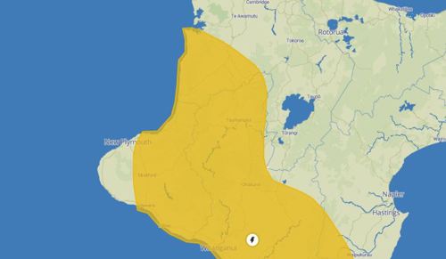
--
9 December 2022 - 11am
Area: Taupo, Taumarunui and inland areas of Waikato and Waitomo
30 November 2022 - 8am
--
23 November 2022 - 10.40am UPDATE
Soundy Road site will be cleared relatively easily
Pukerimu Road will remain closed for some time. We will be making further assessments over the next few days
Tumutumu Road is still closed
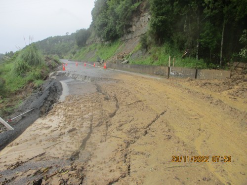
--
23 November 2022 - 8am:
After the heavy rain last night, there are a few damages/slips on our roading network.
Tumutumu road is closed
Pukerimu road has a significant slump and is closed.
Soundy road closed
Mangaokewa Stream is also very high, so please stay away from the banks.
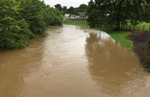
--
18 August 2022 - 1pm:
Weather Warning for Waitomo - Monitoring
)